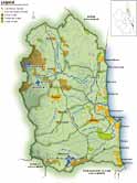
 Subcatchments of the Maroochy and Mooloolah Catchments
- Maroochy River Estuary
- North Maroochy River & South Maroochy River
- Coolum Creek
- Yandina Creek
- Petrie Creek
- Yandina Creek
- Paynter Creek
- Eudlo Creek
- Stumer Creek
- Beaches & Coastal Waters
The Maroochy and Mooloolah River catchments are set in the middle of the Sunshine Coast to the east of the Blackall Range. The catchments have rich, fertile soils and high rainfall. Many of the smaller creeks in the catchment begin their journey to the sea in the rolling, green foothills of the Blackall Range. The creeks gradually join and enlarge, moving down from the hills to flow through the fertile, alluvial floodplains that were once covered in dense tropical rainforest. In many places, these floodplains are now a patchwork of sugarcane and small crops. The rivers flow on through melaleuca wetlands and mangroves, until they reach the coast at the townships of Maroochydore and Mooloolaba. Beautiful white sand surf beaches stretch along the coast to the east of the two catchments, from Coolum to just north of Caloundra, broken only by the rocky headlands at Point Cartwright (Mooloolaba).
More on Maroochy
The major tributaries of the Maroochy include the North and South arms of the river, Coolum, Petrie, Paynter and Eudlo Creeks. Three tiny coastal streams Currimundi, Stumers and Tooway Creeks also flow directly into the sea. The catchment of the Maroochy River is diverse, encompassing several major population centres and extensive agricultural areas as well as large forested areas. The catchment area is 642km2, lying between the Blackall Range and the coast. Population centres in the catchment include Eumundi, Nambour, Eudlo and Coolum, as well as Maroochydore at the river mouth. Cooloolabin and Wappa Dams drain into the South Maroochy Rive, which joins the North Maroochy River just south of Yandina. This junction is approximately 24km upstream from the ocean and represents the tidal limit of the estuary. There are three other main tributaries, Coolum Creek, Petrie Creek and Eudlo Creek. Stumers Creek is a significant stream to the Coolum area and flows directly into the ocean.
More on Mooloolah
The Mooloolah River system drains a relatively small catchment with an area of 194km2 that extends 25km inland from the coast. It is situated between a series of coastal ranges of moderate elevation (~400m). in the west and the Pacific Ocean in the east. The river is formed by many spring-fed rivulets in the Blackall Range upstream of the Mooloolah township.The Jowarra Sate Forest is a cool, shady rainforest that grows down to the banks of the upper Mooloolah River. This is how a large part of the Maroochy and Mooloolah catchments used to look. The trees shade the river, which lowers the water temperature and increases the amount of available oxygen. This allows a greater diversity of plant and animal life to survive in the water. More shade also reduces the growth of nuisance algae and the likelihood of blooms. The rainforest trees also stabilise the banks of the river, protecting it from erosion and filtering rainfall run-off.
The majority of grazing is practiced towards the upper catchment areas and sugar cane farming is concentrated on the flood plains around the tidal limit.Much of the upper freshwater catchment still contains substantial areas of native vegetation, including rainforests with rare and endangered plants such as king ferns and orchids. By contrast the lower coastal areas abutting the estuary have largely been cleared and transformed into urban areas, particularly canal estates. Large-scale landscape modifications have radically altered the nature of the lower Mooloolah estuary, changing a relatively small estuary that drained coastal wetlands into a system that is today completely dominated by residential canal estates, marinas, harbours and artificially stabilised banks. The catchment is contained within the Maroochy Shire Council and Caloundra City Council local government areas.