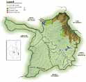
 Subcatchments of the Mid-Brisbane Catchment
- Spring Creek
- England Creek
- Black Snake Creek
- Branch Creek
- Lake Manchester
- Borallon / Mt Crosby
- Mid-Brisbane River
The Mid Brisbane River section extends from Mt Crosby Weir to the Wivenhoe Dam wall approximately 150km from the river mouth. This stretch of the Brisbane River is used as a natural water supply conduit for raw water releases from Wivenhoe Dam to Mt Crosby Weir. Water is released from Wivenhoe Dam every day through the regulators, and takes approximately two days to flow down the 61.5km of river channel to Mt Crosby. The volume of water released changes on a day-to-day basis depending on demand from bulk water customers. The water treatment facility at Mt Crosby supplies drinking water to more than 1.5 million residents in south-east Queensland. Major townships located in the Mid Brisbane River catchment are Fernvale, Lowood and Coominya. The Mid Brisbane River is an important regional resource for recreation, as it is close to major population centres and easily accessible.
The Mid Brisbane River sub-catchment is relatively small (547km2). The larger Lockyer Creek catchment (2971km2) discharges into the Mid Brisbane River 4km downstream from Wivenhoe Dam wall but flow is controlled by O Reillys Weir. Brisbane Forest Park (part of the D Aguilar Range) borders the sub-catchment to the north-east, and the expansive Lockyer Valley agricultural area abuts it to the south-west. Major streams flowing into the Mid Brisbane River are Lockyer Creek, Black Snake Creek, Sandy Creek, Banks Creek and England Creek. The dominant land uses in the catchment are grazing, managed native forests and intensive agriculture, while 44% of the catchment remains as natural bush.